Date/Time
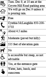
Date(s) - 12/09/25
10:00 am - 1:00 pm
Location
Stanford Dish
Categories
Stanford Dish (Palo Alto)
Meet at: the entrance to the Stanford Hiking Trail Loop, junction of Stanford Avenue and Junipero Serra Boulevard.
Place: The Stanford dish loop is one of the most popular hikes and runs on the entire peninsula. It is named after the large old radio telescope still used for research in the Stanford foothills. The dish is visible from throughout the area. Rain or shine, you’ll find hundreds of locals and Stanford students walking or jogging the trail. The loop has a few very steep (but short) hills; otherwise, it is a nice rolling hike. The paved trail climbs the hills and offers spectacular views of the peninsula, the campus and the coastal mountains. On a clear day, visitors can see San Francisco, Oakland, San Jose, and the East Bay.
There is a porta potty at the entrance to the Stanford Trail Loop.
Directions: From I-280, exit at Page Mill Road and head north (toward the bay) for about ½ mile. Turn right onto Coyote Hills Road. You may park on either side of the road. From there, we will walk ¼ mile to the entrance of the hike. Carpool if possible.
Google Coyote Hills Road, Palo Alto 94304.
If you want to cancel your reservation/sign up:
Call or send an email message to the event leader and inform the leader of your cancellation. (camclaugh7@yahoo.com or call Cynthia McLaughlin at 650-208-0703)
Bookings
Bookings are closed for this event.